
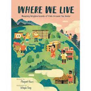
 This intriguing book is a fun look at sixteen children’s neighborhoods around the world. First, there is a helpful page with information about maps, compass roses, legends, and scale bars. Next, we meet the children and learn about their neighborhoods – where they live, go to school and play, what they eat, and sometimes their religions. Maps of each child’s neighborhood show important places, a legend, and some words from the child’s language. The places featured are the Cook Islands, Canada, the United States, Honduras, Venezuela, Antarctica, Spain, the Netherlands, Romania, Egypt, Ethiopia, Zambia, Pakistan, India, China, and Cambodia. Both small communities and big cities are included. Back matter provides activities, a glossary, an author’s note, a further-reading list, and an index. A world map with all the locations is presented on the endpapers. The digitally rendered artwork is perfect for the book. mjw This intriguing book is a fun look at sixteen children’s neighborhoods around the world. First, there is a helpful page with information about maps, compass roses, legends, and scale bars. Next, we meet the children and learn about their neighborhoods – where they live, go to school and play, what they eat, and sometimes their religions. Maps of each child’s neighborhood show important places, a legend, and some words from the child’s language. The places featured are the Cook Islands, Canada, the United States, Honduras, Venezuela, Antarctica, Spain, the Netherlands, Romania, Egypt, Ethiopia, Zambia, Pakistan, India, China, and Cambodia. Both small communities and big cities are included. Back matter provides activities, a glossary, an author’s note, a further-reading list, and an index. A world map with all the locations is presented on the endpapers. The digitally rendered artwork is perfect for the book. mjw |
| Title: Where We Live: Mapping Neighborhoods Of Kids Around The Globe Author: Margriet Ruurs Illustrator: Wenjia Tang Publisher: Kids Can Press Ltd., Toronto Copyright: 2022 Original Language: English ISBN: 978-1525-3013-77 Hardcover pages: 40 Age range: 7-10 Genre: Information Book, Nonfiction Book setting: Sixteen locations around the world Author’s ethnicity: Canadian Author’s residence: British Columbia Illustrator’s ethnicity: Chinese Illustrator’s residence: New York City Subjects: Communities, Customs, Explorations, Human settlements, Mapping, Maps, Neighborhoods, Traditions |
Where We Live: Mapping Neighborhoods Of Kids Around the Globe
Leave a reply
